


i-Boating :Greenland - Marine / Nautical Charts & Navigation Maps app for iPhone and iPad
Developer: Bist LLC
First release : 19 Jul 2016
App size: 45.31 Mb
GPS Marine Charts App offers access to charts covering Greenland. First marine GPS app to have route assistance with Voice Prompts for marine navigation. You can create new boating routes or import existing GPX/KML routes. It supports Nautical Charts course up orientation. Includes Tide & Currents prediction.
►FEATURES
√ Download Beautiful & detailed Hardware/GPU accelerated vector charts (text stays upright on rotation)
√ Query details of Maritime object (Buoy, Lights, Obstruction etc).
√ Custom depth(Ft/Fathom/Meter) & distance units (km/mi/NM)
√ Custom Shallow Depth.
√ Record tracks, Autofollow with real-time track overlay & predicted path vector.
√ Voice Prompts for marine navigation (requires GPS )
√ 1ft / 3ft depth contour maps for anglers for selected lake maps. Useful for fishing/trolling(freshwater/saltwater).
√ Supports GPX/KML for boating route editing/import.
√ Tide & Currents.
√ Seamless chart quilting. Map details from Coastal, Approaches,Harbour, Inland Encs(rivers), and general ENC (Electronic Marine Charts) are automatically mapped to correct zoomlevel
√ Enter / import Waypoints.
► MAPS
Get all the details that you find in your chartplotters!
The maps include coverage of coast of Greenland(derived from GST/KMS data).
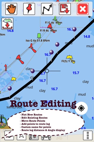
►ROUTE MANAGEMENT / TRIP PLANNING
√ Create New /Edit Routes
√ Reverse Routes
√ Enter,Move, Add, Delete, Rename Waypoints
√ Import GPX, KML & KMZ files
√ Plot/Edit Routes
√ Share/Export Routes, Tracks & Markers
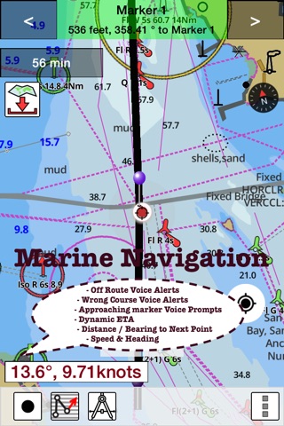
►GPS FEATURES
√ Auto Follow
* Real Time Track Overlay
* Predicted Path Vector
* Course Up (Text stays upright)
* Speed & Heading
√ Route Assistance With Voice Prompts
* Prompts when approaching a boating route marker
* Continous distance & ETA updates
* Alerts when sailing/boating off route
* Alerts when boating in wrong direction
√ Record Tracks
►TIDE & CURRENTS
* For US, Canada, UK,Germany&New Zealand
* High/Low Tides
* Tidal Current Prediction
* Active Current Stations
►CHARTS INCLUDED
√Alanngorsuaq
√Approach to Nuuk
√Aqissersiorfik - Nuuk (Rypeø - Godthåb)
√Bang havn
√Greenland with Surrounding Waters
√Håbets Ø Havn
√Ikerasassuaq
√Ikinnilik
√Itilleq
√Kangaamiut Havn
√Kangerluarsoruseq - Nuuk (Godthåb)
√Kangerluarsorutsimut Pulammagiaa (Approaches to Kangerluarsoruseq)
√Kangerlussuaq
√Kangerlussuarmut Pulammagiaa
√Kangerlussuup Umiarsualivia
√Kangersuatsiaq (Prøven)
√Kapisillit
√Kitsissuarsuit (Hunde Ejland)
√Kitsissut (Kookøerne)
√Maarmorilik
√Maniitsoq
√Maniitsoq North
√Matu Loeb
√Naajaat
√Napasoq
√Narsaq
√Narsarsuaq
√Niaqunngunaq (Fiskefjord)
√Nuuk-Atammik
√Nuup Kangerlua - Kangiata Nunaata Sermia
√Nuup Kangerlua - Kapisillit
√Nuup Kangerlua - Narsap Sermia
√Nuussuaq (Kraulshavn)
√Orsiivik (Polaroil)
√Qaqortoq
√Qaqortorsuannguit-Maliffiup Nunaa
√Qasigissat Spraglebugt
√Qassiisaa
√Qassimiut
√Qeqertarsuatsiaat (Fiskenæsset)
√Qeqertarsuatsiaat (Fiskenæsset) - Kangerluarsoruseq
√Sannerut-Kangilia
√Sequinnersuusaq
√Simiutaq
√Sioqqap Sermia - Qeqertarsuatsiaat (Frederikshåb Isblink - Fiskenæsset)
√Sisimiut
√Skildpadderne - Kangaannguaq
√Talerulik
√Torsukattap Ninninnera (Knækket)
√Upernavik
√Upernavik Harbour
√Uummannap Ikerasaa
√Uummannaq
► SHARING
* Share tracks/routes/markers on Facebook & Twitter
* Export tracks/routes/markers as compressed GPX files.
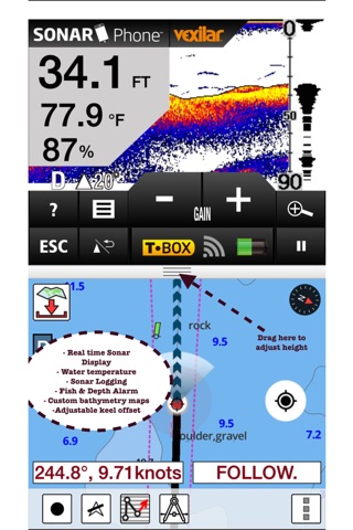
►Instrumentation
√ Marine AIS & (NMEA AIS and GPS over TCP/UDP)
√ Wind direction & Speed,Sonar depth,Water temperature
► Change background to Satellite Imagery
PLEASE NOTE: “Continued use of GPS running in the background can dramatically decrease battery life.”